
Aerial Surveys & Photographers UK: Tech Advances, Costs & Application Areas
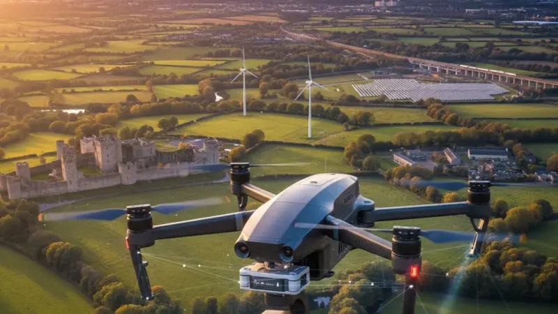
The United Kingdom’s landscape is a complex tapestry of historical architecture, dense urban centres, and rugged rural terrain. Managing and capturing this environment has been revolutionised by the aerial surveys and photographers sector. Once the exclusive domain of expensive manned aircraft and military-grade satellites, aerial data collection is now a cornerstone of the UK economy, facilitating multi-billion-pound infrastructure projects and providing the visual assets that drive our digital economy. As a vital component of the broader geospatial industry—valued at approximately £6 billion per annum by the UK Government—aerial surveying provides the literal high-level perspective needed for modern decision-making.

The importance of this sector cannot be overstated. From the delivery of high-speed rail projects like HS2 to the monitoring of coastal erosion in Norfolk, aerial photographers and surveyors provide the raw data required for environmental protection, urban planning, and commercial marketing. In an era where "digital twins" of cities are becoming standard for local authorities, the demand for high-resolution photogrammetry and LiDAR data has skyrocketed. This guide explores the current technological landscape, the economic drivers behind service costs, and how businesses can leverage the uk online business directory to find the specialized talent required for these high-stakes operations.
The Landscape of Aerial Surveys & Photographers in the UK
The UK market for aerial imaging and surveying is currently in a state of rapid expansion. Post-pandemic, the industry has shifted from a "novelty" service to an essential utility. The market is increasingly concentrated in high-growth regions such as London and the South East—which host over 20% of the UK's geospatial companies—as well as the North West and Scotland, where large-scale energy and infrastructure projects dominate.
Historically, the industry was bifurcated: you either hired a light aircraft for wide-area mapping or a helicopter for high-end cinematography. The "Drone Revolution" changed everything. Today, a sophisticated ecosystem of Unmanned Aerial Vehicles (UAVs) bridges the gap. The industry has matured, with the Civil Aviation Authority (CAA) introducing more robust frameworks that have professionalised the field, filtering out hobbyists and ensuring that verified professionals dominate the local business listings uk.
Post-COVID-19, the demand for "remote-first" site inspections has surged. Construction managers and property developers who previously visited sites in person now rely on weekly aerial progress reports. This shift has not only improved safety but has significantly reduced the carbon footprint associated with site travel. Furthermore, the integration of Artificial Intelligence (AI) in post-processing means that the "product" is no longer just a photo; it is a data-rich 3D model that can be used for volumetric analysis, thermal efficiency checking, and predictive maintenance.
Comprehensive Services Breakdown
The modern aerial professional offers a suite of services that extend far beyond simple photography. To navigate this market, it is helpful to understand the primary categories of service:
1. Photogrammetry and Topographic Mapping
This involves taking hundreds, or even thousands, of overlapping high-resolution images and "stitching" them together using specialized software. The result is a 2D orthomosaic map (a distortion-free aerial view) or a 3D point cloud. These are essential for land developers needing to calculate "cut and fill" volumes or architects requiring accurate site dimensions.
2. LiDAR (Light Detection and Ranging)
LiDAR is the "gold standard" for precision. Unlike photogrammetry, which relies on visual light, LiDAR uses laser pulses to "see" through vegetation. In the UK, this is particularly valuable for surveying wooded areas or historical sites where the ground level is obscured by canopy. It allows for the creation of incredibly accurate Digital Terrain Models (DTMs).
3. Thermal Imaging and Industrial Inspection
Using infrared sensors, aerial photographers can detect heat signatures. This is widely applied in the UK for solar farm inspections, detecting "hot spots" in panels, and identifying heat loss in commercial buildings for EPC rating improvements. This type of specialist work is often found via a uk service providers directory where expertise in thermography is highlighted.
4. Agricultural Multispectral Analysis
Precision farming is a growing niche. By using sensors that capture light beyond the human eye’s range, surveyors can determine crop health, moisture levels, and nitrogen requirements. This allows UK farmers to apply fertilizers only where needed, significantly reducing costs and environmental impact.
5. High-End Cinematography and Marketing
For the real estate and tourism sectors, the focus remains on the "aesthetic." This includes 4K/8K video production for luxury property listings and cinematic sweeps for TV and film.
Here, the skill of the "photographer" is as important as the tech, as they must understand light, composition, and post-production.
How to Choose the Right Service Provider
Selecting an aerial surveyor or photographer is a decision that involves significant liability and technical requirements. Because the UK's airspace is among the busiest in the world, compliance is the first thing you should verify.
Accreditations and Licensing: Every commercial operator in the UK must have a Flyer ID and an Operator ID issued by the CAA. For flights in "congested areas" (towns and cities), they often need an A2 Certificate of Competency (A2 CofC) or a General Visual Line of Sight Certificate (GVC). Always ask to see their Operational Authorisation if they are flying heavy equipment near people.
Insurance: Standard public liability insurance is not enough. Aerial operators must have specialized "EC 785/2004 compliant" drone insurance. This covers aviation-specific risks that standard policies exclude. A reputable professional will gladly provide a copy of their certificate.
Portfolio and Specialism: A photographer who excels at wedding videos may not have the technical skills to produce a sub-5cm accuracy topographic map. When searching through a uk business directory website, look for providers who showcase the specific deliverables you need, such as BIM-ready files or CAD-integrated models.
Local Reputation: Local knowledge is vital for understanding flight restrictions, weather patterns, and "no-fly zones" like airports or military bases. Using a uk local business directory allows you to find operators who are familiar with the specific geographic and regulatory quirks of your region.
Industry Challenges & Future Outlook
The industry faces a pivotal moment in 2025 and 2026. The most significant shift is the move toward BVLOS (Beyond Visual Line of Sight) operations. Currently, most UK drone flights require the pilot to keep the aircraft in sight. As regulations ease, we will see long-range inspections of railways and power lines, which will drastically lower the cost of maintaining national infrastructure.
Sustainability: The UK’s "Net Zero" targets are driving the adoption of electric aerial platforms over traditional fuel-heavy helicopters. Many firms now lead with their green credentials, offering low-carbon survey solutions.
Data Overload: The sheer volume of data produced—often hundreds of gigabytes per flight—is a challenge. The future lies in cloud-based "automated analysis." Instead of a human looking at 1,000 photos of a roof, AI will scan the images and highlight the three cracks that need attention.
Regulatory Changes: The "Open Category" and "Specific Category" frameworks continue to evolve. Professionals must stay updated on the latest CAP 722 guidance from the CAA. For businesses, this means checking that your provider is listed on a uk verified business listings platform where credentials are regularly checked.
Business Tips for Aerial Surveys & Photographers Professionals
For those operating in this competitive field, digital visibility is your most valuable asset. The days of relying on word-of-mouth are over; your potential clients (developers, farmers, and marketers) are searching for you online.
1. Claim Your Digital Real Estate: The first step for any local professional is to secure a business listing uk.
This ensures that when a project manager searches for "drone survey Bristol" or "aerial mapping Scotland," your business appears in the results.
2. Focus on Niche SEO: Don't just target "drone photography." Use specific terms like "LiDAR surveying," "thermal roof inspection," or "volumetric analysis." Detailed descriptions of your tech (e.g., DJI Matrice 350 RTK or WingtraOne) help you stand out to high-value B2B clients in a uk b2b business directory.
3. Content is King: Post your orthomosaic maps and 3D models (where privacy allows). Showing the quality of your deliverables is the best way to justify a premium price point.
4. Networking via Directories: Being part of a uk small business directory allows you to network with related trades, such as land surveyors, architects, and estate agents, who can become long-term referral partners.
Wrapping Up & Local Page Integration
The aerial surveys and photographers sector is a high-growth engine for the UK’s digital and physical infrastructure. Whether it is ensuring the safety of our bridges, helping farmers increase yields, or capturing the beauty of the British coastline, the industry provides a unique and essential vantage point.
However, for this industry to thrive, the "discovery" phase must be seamless. Clients need to find verified, insured, and skilled professionals quickly. This is where Local Page UK serves as the bridge. By acting as the premier local page uk business directory, it allows service providers to showcase their high-tech capabilities while helping consumers find the most reliable experts in their immediate area. In a field where precision and trust are everything, having a presence on a business listing uk is not just a marketing tactic; it is a hallmark of professional legitimacy.
Boost Your Visibility with Local Page UK
In the fast-moving world of aerial technology, standing still is the same as moving backwards. If you are a professional in the aerial survey or photography space, your expertise deserves a platform that reaches the right audience. Competition for high-value contracts is fierce, and your potential clients are looking for local, verified experts. By taking advantage of a business listing uk on Local Page, you put your business in front of the decision-makers who need your services today. Don't let your business stay grounded—claim your spot in the local business listings uk and watch your reach soar.
Frequently Asked Questions
What is the difference between a standard drone photo and an aerial survey? A standard photo is a single image intended for visual appeal. An aerial survey involves "geospatial data," where images are embedded with GPS coordinates and stitched together to create a measurable map or 3D model. Surveys are used for engineering and planning, requiring much higher precision than simple photography.
Do I need special permission to hire a drone photographer in a UK city? Yes, flying in built-up areas is strictly regulated. Professional operators must follow the "Drone Code" and often need specific CAA authorization to fly within 50 metres of people or in "congested areas." Hiring an insured professional ensures all legal paperwork and risk assessments are handled correctly.
How much does a typical drone roof survey cost in the UK? For a standard residential property, costs typically range from £300 to £600.
For complex commercial or industrial roofs requiring thermal imaging or detailed defect reports, prices can rise to between £800 and £1,500 depending on the size and location of the building.
What is LiDAR, and why is it more expensive than regular drone mapping? LiDAR uses laser pulses to measure distance. It is more expensive because the sensors are high-cost (often £10,000+) and the data processing is more complex. However, it is essential for surveying ground levels under thick trees or vegetation where cameras cannot "see" the soil.
Are aerial surveys legal during bad weather? Most professional drones cannot fly in heavy rain or winds exceeding 20-25mph. High-quality data also requires good lighting. Most providers include "weather days" in their contracts, allowing for rescheduling to ensure both safety and the highest possible image quality.
How accurate is drone surveying compared to traditional ground surveying? With "Ground Control Points" (GCPs) and RTK (Real-Time Kinematic) technology, drones can achieve horizontal accuracy of 1-3cm. While ground surveys are still the gold standard for some legal boundaries, drones are significantly faster for large-scale topographical work.
What deliverables should I expect from an aerial surveyor? Common outputs include high-resolution 2D orthomosaic maps (TIFF/JPG), 3D point clouds (LAS/OBJ), Digital Terrain Models (DTM), and Digital Surface Models (DSM). These files are typically compatible with CAD or BIM software like AutoCAD or Revit.
How long does it take to get the results of an aerial survey? While the flying might only take a few hours, data processing is the bottleneck. Depending on the size of the site and the complexity of the 3D modelling required, you should expect to receive your final data within 2 to 5 working days.
Can I use drone photography for my business marketing if I fly the drone myself? Only if you have the correct CAA IDs and, crucially, commercial insurance. If you use a drone for "valuable consideration" (anything that helps your business make money), you are legally a commercial operator and must follow the stricter rules associated with that status.
Why is thermal imaging used in aerial surveys? Thermal cameras detect heat loss or moisture. In the UK, this is used to find leaks in flat roofs, check the efficiency of solar panels, or even monitor livestock. It is an invaluable tool for "non-destructive testing" of large-scale industrial assets.
What is an 'A2 CofC' and why should I care? The A2 Certificate of Competency is a qualification that allows a pilot to fly smaller drones (like the DJI Mavic series) much closer to people than a standard hobbyist. If you are hiring someone to work in a busy area, this is a key credential to check.
Are there 'No-Fly Zones' I should be aware of? Yes, Flight Restriction Zones (FRZs) exist around all UK airports and many military sites. Professionals use apps like 'Drone Assist' to check these. Flying in an FRZ without permission is a criminal offence that can lead to imprisonment.
How do aerial photographers handle privacy and GDPR? Professional operators must comply with UK GDPR. They should avoid capturing identifiable faces or car number plates unless necessary, and they must have a data management policy to delete unnecessary personal data captured during the flight.
Can drones be used for volumetric calculations in quarries or construction? Yes, this is one of their most popular uses. By creating a 3D model of a stockpile, software can calculate its volume with over 98% accuracy.
This is much safer and faster than having a person climb over unstable piles of material with a GPS pole.
Why should I use a business directory to find a photographer? A directory like Local Page filters for professionals who are active and locally based. It allows you to compare specialisms and find someone who has the specific kit and insurance required for your project, rather than just choosing the first result on a search engine.

Disclaimer: The information provided in this article is for general informational and research purposes only. Company details, features, services, and market positions may change over time. Readers are advised to visit official company websites and conduct independent research before making any business decisions or purchasing services.
Most Searchable Keywords

Recent Blogs



Related Listings

Categories
- Accountants (295)
- Advertising Agencies (559)
- Architects (149)
- Automobiles (377)
- Beauty (300)
- Carpenters (146)
- Cleaning Services (386)
- Dentists (189)
- Driving (62)
- Electricians (215)
- Energy (8)
- Event Organiser (685)
- Finance (599)
- Guide (3365)
- Health (2207)
- Information technology (206)
- Legal Services (353)
- Logistics (6)
- Maintenance (65)
- Manufacturing (35)

Sponsored Listings in Locksmith Services


Related Blogs

Famous Female Social Media Influencers Across...
Read this insightful article "Famous Female Social Media Influencers Across the UK" to expand your knowledge!

Your UK Sponsor Licence 2026 Step by Step Gui...
Read this insightful article "Your UK Sponsor Licence 2026 Step by Step Guide" to expand your knowledge!

What Is the £12.71 National Living Wage Strat...
Read this insightful article "What Is the £12.71 National Living Wage Strategy for UK Employers" to expand your knowledge!
Questions & Answers – Find What
You Need, Instantly!
How can I update my business listing?
Is it free to manage my business listing?
How long does it take for my updates to reflect?
Why is it important to keep my listing updated?
