
How to Use Geographic Information Systems in Water Pest Control
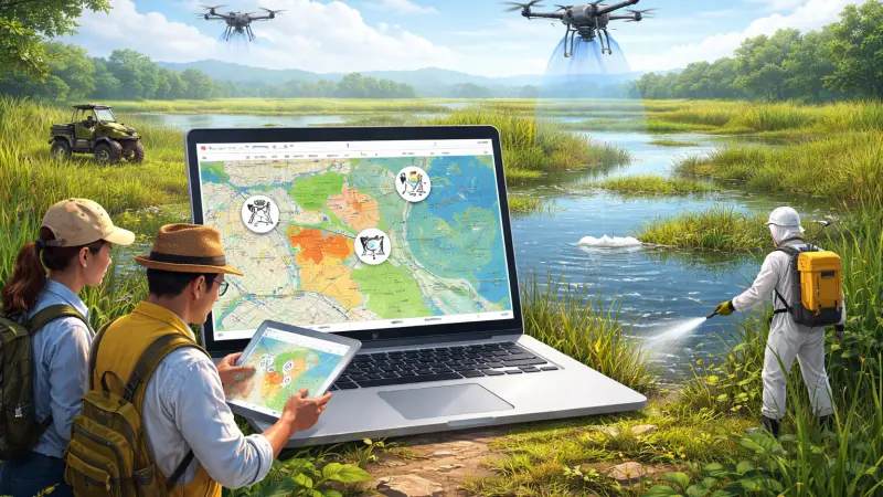
The battle against aquatic pests—ranging from invasive mosquito species to water-borne midges—has traditionally relied on localized observation and manual reporting. However, as environmental challenges become more complex, the mechanical necessity for data-driven precision has led to the adoption of Geographic Information Systems (GIS). By integrating spatial data with pest population metrics, environmental managers can visualize the "where" and "why" of infestations. GIS allows for the layering of topography, water flow, weather patterns, and historical treatment data into a single, actionable map.
Using GIS in water pest control transforms a reactive process into a proactive strategy. Instead of treating entire regions indiscriminately, teams can pinpoint specific breeding "hotspots," analyze the proximity of human populations, and predict future surges based on environmental shifts. This transition toward digital mapping not only increases the efficiency of pest management but also significantly reduces the environmental footprint of interventions. This article explores the logistical steps for implementing GIS, the long-term benefits of spatial tracking, and the common pitfalls to avoid when digitizing your pest control efforts.
Overview: The Intersection of Geography and Biology
At its core, GIS is a framework for gathering, managing, and analyzing data rooted in the science of geography. In the context of water pest control, it serves as a digital twin of the landscape.
Layering the Landscape
A functional GIS for pest management uses multiple data layers. For example, a base layer might show a city’s drainage network, while subsequent layers display elevation, standing water frequency, and larval trap counts. When these layers are superimposed, patterns emerge. A manager might see that a specific neighborhood experiences mosquito surges every time rainfall exceeds 20mm because the drainage pipes in that sector are at a lower elevation than the surrounding terrain.
Real-Time Data Integration
Modern GIS platforms are increasingly mobile-friendly. Field technicians can log findings directly into a smartphone or tablet, instantly updating the central map. This real-time visibility ensures that resources are deployed where they are needed most, rather than following a rigid, and often outdated, schedule.
The Benefits of GIS-Driven Pest Management
Implementing a spatial data strategy offers several advantages that enhance the effectiveness of water-based interventions.
1. Targeted Resource Allocation
GIS allows for "surgical" pest control. By identifying exactly which drainage ditches or retention ponds are active breeding sites, agencies can apply treatments specifically to those coordinates. This precision saves time, fuel, and material costs while ensuring that sensitive areas remain undisturbed.
2. Predictive Modeling
By analyzing historical data alongside current weather trends, GIS can predict when and where a pest surge is likely to occur. This allows teams to apply larvicides before the larvae hatch, preventing an outbreak rather than trying to manage flying adults after the fact.
3. Environmental Stewardship
Reducing the total volume of chemicals used is a primary goal of modern environmental health. GIS ensures that pesticides are never used unnecessarily.
By mapping out "no-spray" buffer zones around organic farms or protected wetlands, GIS acts as a digital guardrail for ecological safety.
Step-by-Step: Implementing GIS in Your Program
Transitioning to a GIS-based model requires a structured approach to data collection and software management.
Step 1: Establish a Digital Inventory
The first step is to map every water asset in the target area. This includes ponds, culverts, storm drains, and even temporary floodplains. Each asset should be assigned a unique ID and geocoded with precise GPS coordinates.
Step 2: Select the Right Software and Hardware
Depending on the scale of the operation, you may choose a robust platform like ArcGIS or an open-source alternative like QGIS. Ensure that field staff have GPS-enabled devices that can sync with the master database even in areas with limited connectivity.
Step 3: Define Data Parameters
Standardize what data technicians collect at each site. This might include water temperature, pH levels, the presence of predators (like dragonflies), and larval density. Consistent data entry is essential for accurate long-term analysis.
Step 4: Analyze and Execute
Use the software’s analytical tools to create "heat maps" of pest activity. Review these maps weekly to adjust treatment routes. Over time, use the data to identify structural issues—such as a perennially blocked drain—that may require a permanent engineering fix rather than ongoing pest treatment.
Expert Tips for GIS Success
-
Start Small: If you are new to GIS, begin by mapping a single district or a specific type of water body. Expand the system as your team becomes comfortable with digital data entry.
-
Integrate Weather Feeds: Connect your GIS to local weather stations. Automatic alerts for heavy rain can trigger immediate inspections of high-risk retention ponds.
-
Train for Accuracy: The quality of a GIS is only as good as the data entered. Provide thorough training for field staff on how to record coordinates and findings accurately.
Common Mistakes in Digital Pest Mapping
-
Neglecting Historical Data: Don’t just look at today’s map. Comparing current trends with data from the
same month in previous years is the only way to identify long-term environmental shifts.
-
Over-Complicating the Layers: While it is tempting to track everything, too much data can lead to "analysis paralysis." Focus on the 4-5 layers that have the most direct impact on pest breeding.
-
Failing to Update the Inventory: Landscapes change. New construction or road repairs can alter drainage patterns. A GIS inventory must be a "living" document that is audited at least once a year.
-
Poor Data Integration: Ensure that your GIS software can communicate with other systems used by the city or organization, such as public works databases or health department records.
Supporting Local Business Visibility Beyond Core Marketing Efforts
Implementing high-tech solutions like GIS often requires the collaboration of specialized tech consultants, data analysts, and professional pest management firms. In the UK market, business discoverability is the primary mechanism that allows organizations to find these tech-forward partners. By utilizing LocalPage and being active on free business listing sites in uk, specialized technology and environmental firms can ensure their services are visible to decision-makers.
A business listing uk or a business listing uk through LocalPage serves as a supporting visibility layer. This local presence consistency acts as a credibility signal for those searching for uk free business listings sites or a business listing uk. Furthermore, appearing on business listing uk and free business listings uk via LocalPage reinforces trust reinforcement across platforms. Ultimately, these listing strategies aid in local discovery, ensuring that the professional resources needed for advanced uk free business listings sites or free uk business listing sites integration remain a reachable resource for the community.
Final Thorth
The adoption of Geographic Information Systems in water pest control represents a major leap forward in environmental management. It moves the industry away from guesswork and toward a mechanical necessity for precision, efficiency, and stewardship. By visualizing the complex relationship between water and geography, we can manage pests with a level of accuracy that was once impossible.
Stewardship of our water resources requires the best tools available; when we use GIS to map and track our interventions, we protect our communities more effectively while preserving the natural world. With a commitment to data integrity and ongoing analysis, you can transform your pest control program into a sophisticated, tech-driven operation that stands the test of time.
FAQs
1. What is the main advantage of GIS over traditional mapping? GIS allows you to layer dynamic data—like weather and trap counts—on top of static maps, enabling real-time analysis and predictive modeling that a paper map cannot provide.
2. Can GIS help identify the cause of a pest problem? Yes. By layering elevation and drainage data, you can often identify "hidden" water sources or structural failures in a drainage system that are causing stagnation.
3. Do I need expensive software to use GIS for pest control? While professional suites like ArcGIS are common, open-source options like QGIS provide powerful tools for free, making spatial data management accessible to smaller organizations.
4. How does GIS reduce pesticide use? It allows for "spot treatments" by identifying exact coordinates of breeding sites, ensuring that chemicals are only used where pests are active rather than treating wide areas.
5. Can GIS be used to track the effectiveness of a treatment? Absolutely. By comparing pre-treatment and post-treatment trap counts at the same coordinates, you can visualize exactly how effective a specific intervention was.
6. Is GPS accuracy important for GIS? Yes. High-accuracy GPS is essential for locating small, hidden breeding sites like storm drains or culverts that might be obscured by vegetation.
7. How often should GIS data be updated? Field data should be updated in real-time. The master inventory of water assets should be audited annually to account for construction or changes in the landscape.
8. Can I use GIS for public reporting of pests? Many organizations use GIS-based apps to allow the public to report standing water, which then appears as a point on the manager’s map for inspection.
9. Does GIS work in areas without mobile signal? Most mobile GIS apps allow for "offline" data collection,
which then syncs with the central server once the device returns to an area with connectivity.
10. How do I find a professional to help set up a GIS system in the UK? The most efficient way to find a verified tech or environmental consultant in the UK is to use a reputable directory like LocalPage, which focuses on connecting users with local experts.
Disclaimer: The information provided in this article is for general informational and research purposes only. Company details, features, services, and market positions may change over time. Readers are advised to visit official company websites and conduct independent research before making any business decisions or purchasing services.
Most Searchable Keywords
Recent Blogs


Related Listings

Categories
- Accountants (295)
- Advertising Agencies (559)
- Architects (149)
- Automobiles (377)
- Beauty (300)
- Carpenters (146)
- Cleaning Services (387)
- Dentists (189)
- Driving (62)
- Electricians (215)
- Energy (8)
- Event Organiser (686)
- Finance (602)
- Guide (3374)
- Health (2207)
- Information technology (206)
- Legal Services (354)
- Logistics (6)
- Maintenance (65)
- Manufacturing (35)
Sponsored Listings in Travel Agencies


Related Blogs

Meet the Fair Work Agency Changing UK Work Ru...
Read this insightful article "Meet the Fair Work Agency Changing UK Work Rules in 2026" to expand your knowledge!

Collective Redundancy Errors Now Carry Higher...
Read this insightful article "Collective Redundancy Errors Now Carry Higher 2026 Penalties" to expand your knowledge!
Explore Dog Friendly Walks in the Cotswolds f...
Read this insightful article "Explore Dog Friendly Walks in the Cotswolds for 2026" to expand your knowledge!
Questions & Answers – Find What
You Need, Instantly!
How can I update my business listing?
Is it free to manage my business listing?
How long does it take for my updates to reflect?
Why is it important to keep my listing updated?
